“It’s a culmination of your life of surfing when you turn and paddle in at Mavericks.”
— Jeff Clark
“Big waves aren’t measured in feet, but in increments of fear.“
— Buzzy Trent
Mavericks Monsters from Elijah Crowell on Vimeo.
The Reef Beneath
While surfing I have always been torn between watching the waves or looking underwater at the reef and critters beneath me. As terrestrial mammals, we tend to focus on surface manifestations and less on the aquatic. In this series of posts, I focus on the narrow interface between the ocean surface, the propagation of waves, the reefs they encounter, and the sea life below. A happy merger of my interests as a surfer and marine biologist. Anyone who has taken a tour of the seafloor beneath their favorite surf spot cannot help but appreciate the reef, and how it influences the waves and marine life alike. Here is their story….
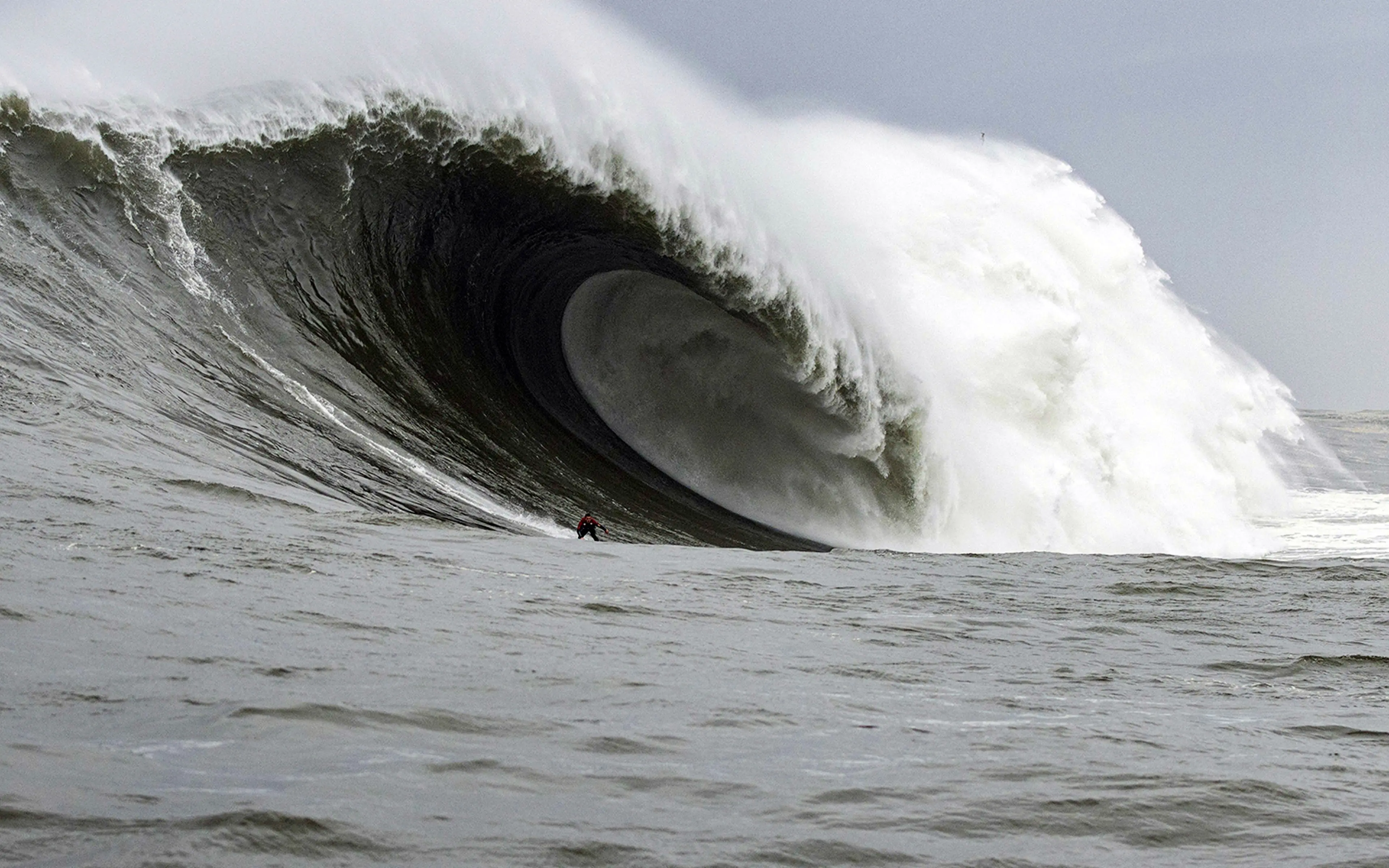
Maverick’s
Never surfed this spot, never will. Just hearing the name scares me. I can feel the power of those huge waves, see them doubling up on the massive reef, thick hollow lip keeling over onto the jagged bottom exploding in an avalanche of water that sweeps into a labyrinth of sharp rocks. A wave that is both your ultimate dream and your worse nightmare. Clark, Virostko, Ambrose, Washburn, Long, Dollar, Tashnick, Collins, Moriarity, Healey, Baker . . . the top Maverick’s surfers are, well, Titans. Just a step below the gods but not immortal. Through years and decades of dedication they have mastered the art of surfing the largest, nastiest, perfect wave in the world; and in turn, have conquered their fear of the ultimate big wave machine.
The wave at Maverick’s is unique in many ways: its location, the geology and geomorphology (shape) of the reef, and the massive swells that surfers ride. In many ways, Maverick’s allure is the story of its reef, which is legendary for creating both a perfect large wave and a reef seemingly designed to punish those attempting to ride it (Figure 1). As if the reef and wave weren’t enough you can add the fact that great white sharks frequent the area and occasionally clear the lineup with their presence; at least one surfer has been attacked in the lineup: Tim West in 2005. In the early days, before it became popular, surfers knew it would eventually kill people with its strong currents, long period swells, 10-15 wave sets and multi-layered inner reef full of valleys, holes, and crevasses leading into a boneyard of exposed, jagged rocks. And it has.

Location
Maverick’s is ideally located for massive swells. When storms churn out of the north Pacific they have over 3,300 nautical miles (vs. 1,900 nm for Hawaii) over which to mature before reaching Pillar Point (See Sponsler, 2006 in: Inside Maverick’s). A few hundred miles further north there would be unfavorable winds, a few hundred miles south and the waves would be smaller. The result is that Mavericks can hold 30-foot waves composed of 10-15 wave sets, with 25-second periods between waves — ideal for big wave conditions but bad news if you are caught inside or wipeout on the first waves of the set. In 1999 Maverick’s had waves with 70-foot faces and it can generate 100-foot waves as two water safety patrollers found out on jet skis in 2001.
Geology and geomorphology

The rocks which comprise the reef and much of the nearby area was formed as part of the Purisima Formation, a 3-7 million years old seabed composed largely of rock made from mud (mudstones), silt (siltstones), and sand (sandstones) deposits in the ancient Purisima sea. The Purisima formation can be found from Pt. Reyes down to Santa Cruz and older deposits are found in the cliffs near Steamer Lane, Pleasure Point, and the Hook. If you want to learn more about the Purisima formation, including fossil fish and whales, check out the paper by Dr. Robert Boessenecker and colleagues below.
When you examine a geologic map of the reef what you see is the layers of the seabed formed over millions of years that have been deformed by tectonic forces from the San Gregorio fault system and eroded by wind (when sea level was lower) and waves. Maverick’s reef is located between two arms of a fault system, the San Gregorio fault, (Figure 2) and through its strike-slip motion has folded, faulted and rotated the layers of the Purisima sea floor over millions of years to form the reef you see today.* You can get a good look at the formation by examining the rocks inshore of Maverick’s and those in the nearby Fitzgerald Marine Reserve which illustrate the folded and rotated rock layers that form the reef (Figure 3). Why is this important? One reason is that the alternating layers of rock formed at different depths in the sea resulted in mud- sand – and silt-stones which eroded at different rates. This differential erosion has several consequences: 1) the reef has been formed into a series of peaks and valleys; 2) the rocks form jagged edges that can tangle a leash and cause physical damage upon contact; and 2) it creates diverse habitats which can promote a diverse community composed of a wide variety of marine life.

The Reef
Lucky for us, the State of California has invested in multibeam sonar mapping of the the seafloor along most of the State’s coastline. By bouncing sound off the seafloor we can learn both the shape and composition of what lies beneath the waves. When images from these studies were first unveiled in 2007 the topography off Pillar Point revealed a striking picture of the reef and why the wave at Maverick’s is so special (Figure 4). As my colleague, Dr. Rikk Kvitek, director of the Seafloor Mapping Lab at California State University in Monterey Bay said “As soon as I saw that gradual ramping from deep to shallow water, it was, like, wow! That’s why Mavericks happens, I’ve done an awful lot of seafloor mapping and I’ve never seen geology like that before.”

The reef itself extends almost a mile offshore and curves from the NW to the west as it approaches the shore; in essence capturing and focusing wave energy directly into the surf spot. This happens through wave convergence (Figure 5) on west and NW swells; other swell directions are either blocked by coastal features to the north or pass by the reef altogether. Wave convergence at Maverick’s is so strong that water in the channels on both sides of the break funnel water onto the reef causing wave faces to double in size. As they build up the advancing wave sucks water off the reef below sea level, further adding to the size of the wave face.

As swells begins to feel the reef they encounters a long, gradual slope from the outer edge, which is about 100 feet deep, onto an abrupt inner reef at 20 ft depths (Figure 6C, Point 1). Here the wave keels over with a massive lip on the Corner in both directions forming a perfect wave. The reef under the corner has been described as a large, smooth mushroom shaped rock. Just shoreward of that is the Trench, a deep water spot surfers may end up pushed into and held down for multiple waves. After that the right break wave reforms over another shallow reef on the Second (or Lates) Bowl at 10-15 ft depths and jacks up again. Those unfortunate enough to wipe out on the wave (which is common) or are caught inside (also common) can be dragged over the Cauldron (Point 2), a shallow series of ledges, valleys and pits (Point 3), where surfers can also become battered against the bottom and trapped or eventually dragged into Sail Rock and its encrusted rock brothers (Point 4) where surfers can be slammed against the jagged edges and have their leash tangled on its sharp edges. Maverick’s also has several outer reefs such as the Outer Bowl (Point 5 and seaward) which can break on large swells with the potential for holding very large waves as the reef extends offshore.
Maverick’s is also famous for waves shifting directions in the lineup and rogue waves, which is why getting caught inside is so common, and scary. It isn’t uncommon on a 15-18 ft day to have 30+ foot plus waves suddenly appear on the horizon and catch everyone inside. This happened to Jacob Trette in 2011 when an entire group of surfers was caught inside which ended with him being pitched over the lip and held down for two waves. Luckily the unconscious Trette was rescued by a photographer on a Jetski and survived the ordeal.

Marine Life
As one could expect a unique reef supports unique marine life and there are studies from the intertidal area near Sail Rock and deeper water studies offshore at 60-120 ft depth using ROVs (Remotely Operated Vehicles) and towed sleds. However, there isn’t much SCUBA diving in the area for several reasons. One, sediments from rivers dumping into San Francisco Bay create a plume of muddy water that extends down to the region. Hence, there are generally only 5-10 stellar days of diving (visibility > 15 ft) each year. Second, the area is within the “red triangle” bounded by Ano Nuevo, the Farallon Islands, and Bodega Bay and thus has a significant great white shark population. Combine those traits with a reef located 1/2 mile offshore and they are not exactly a good combination for sport diving. In fact, the only description of the area I could find was on SpearBoard.com post by Dennis Haussler:
It’s a fish dreamland! HUGE cracks, holes, boulders, drops from 20 to 60 ft, ledges, it’s all there. Problem is, visibility is usually shit, usually decent current, and it is very sharky.
Offshore studies are more revealing and we have two studies to look at. One using a towed sled and another using a Remotely Operated Vehicle (ROV). Both of these studies examined the reef directly offshore of the surf spot (Figure 7).

The first, a project led by Dr. Guy Conchran at USGS using a towed sled was designed to look at the geology of the seafloor to help interpretation of the sonar maps. The video below shows the high vertical relief of the outer reef as it crosses 60 ft depths:
The second project, led by Dr. James Lindholm at Cal State Monterey Bay’s Institute for Applied Marine Ecology, uses an ROV to survey the reef and surrounding area, including its biota. In addition to video, they have published a report describing the marine life in the area around Maverick’s, which is included in a link below.
Some interesting findings from their report:
- Visibility was generally poor in the area;
- Ling Cod and kelp Greenling were the most common fish (Figure 8). Since both of these fish eat small fish and a wide range of invertebrate animals they indicate the reef is biologically diverse, probably due to its complex reef shape;
- Anemones and sponges were common (you can see them in both videos), which is typical of wave exposed reefs;
- Sea stars were super common. Since these fish are largely predators on encrusting and sessile prey, they also indicate high abundances of species typically found on wave exposed coasts (Lindholm et al., 2013).
Thus, as you might expect, the jagged, punishing reef of Mavericks is also a haven for a wide variety of marine critters. So the next time you are surfing look down and imagine all of the wonderful marine life beneath you. But remember to keep your eyes on the waves!

Final Report on North Central California ROV surveys (edited for Pillar Point only): NCC_ROV_FinalReport_Pillar Point (for the full report go here)
References & further reading
The Wave
- Inside Maverick’s: Portrait of a Monster Wave (a must-have book for those interested in Maverick’s)
- Personal watercraft integral to saving surfer’s life (story of Trette’s ordeal)
- Surfline: Maverick’s Surfing Info (general overview of the spot)
- Inside Mavericks, big-wave surfing’s gnarliest contest
- Surfing Mavericks: The Science of Northern California’s Big Waves
- What Surfing Mavericks Can Teach You About Conquering Your Fears
- Surfer Attacked By Great White Shark At Mavericks
- Surfline Maverick’s Poster!
- Sean Collins analyzes Maverick’s (excellent post by the late Sean Collins at Surfline who set the bar for the science of surfing)
- Unique conditions swell Maverick’s monsters
- Desperate race for survival: Riding for their lives (100 foot waves at Maverick’s)
- Videos/Films: Discovering Mavericks (by Josh Pomer), Chasing Maverick’s (Michael Apted & Curtis Hanson)
Geology
- California State Waters Map Series—Offshore of Half Moon Bay, California (detailed USGS data and maps)
- Geological Outings Around the Bay: Fitzgerald Marine Preserve
- California’s underwater terrain: sandstones, folds, and a very active fault
- The unbelievable bathymetry of Mavericks (see this blog for alternate theories of Maverick’s geology)*
- Physics of Mavericks
- High resolution mapping of Mavericks
- Comparative Taphonomy, Taphofacies, and Bonebeds of the Mio-Pliocene Purisima Formation, Central California
Marine Life
- Diving mavericks (SpearBoard forum post)
- An overview of Scuba Diving in San Mateo County
- California Seafloor Mapping Program video and photograph portal (USGS)
- North Central California Coast MPA ROV surveys (Cal State Monterey Bay)
12 responses to “What Lies Beneath: the Waves, Reef and Marine Life of Maverick’s”
Reblogged this on digger666.
[…] What Lies Beneath: the Waves, Reef and Marine Life of Maverick’s: a broad overview of a popular surf spot from both a surfer’s and scientist’s perspective […]
[…] Given the bathymetry, a 15-ft, 20-s period wave could easily grow to 4-5 times its height creating a 60-75 ft wave (Dixon, 2011). In a big swell, a perfectly-shaped 100 ft wave could be generated; during a once-in-a-century El Niño-type swell, a 1,000 ft wave is possible. All the other big wave spots, such as Jaws, Maverick’s and Todos Santos, begin closing out at 50-100 ft heights into a huge, unrideable wave. […]
[…] What Lies Beneath: the Waves, Reef and Marine Life of Maverick’s […]
[…] What Lies Beneath: the Waves, Reef and Marine Life of Maverick’s: a broad overview of a popular surf spot from both a surfer’s and scientist’s perspective […]
Fantastic post! Love the combination of your expertise and waterman experience!
Thank you! Love your site too
[…] in advancing the equity issue in professional surfing at Maverick’s, one of the most challenging big waves in the […]
[…] What Lies Beneath: the Waves, Reef and Marine Life of Maverick’s […]
[…] in such an isolated wave on a monster, unforgiving wave and shallow, sharp reef? Like Jeff Clark at Maverick’s, who surfed it for years by himself far offshore but in plain sight, shippies extreme isolation […]
[…] What Lies Beneath: the Waves, Reef and Marine Life of Maverick’s […]
[…] spots have their legends, and a few have big legends. Some, like Waimea Bay and Mavericks, had a high bar separating the waves from us mere mortals. But once men summoned the […]